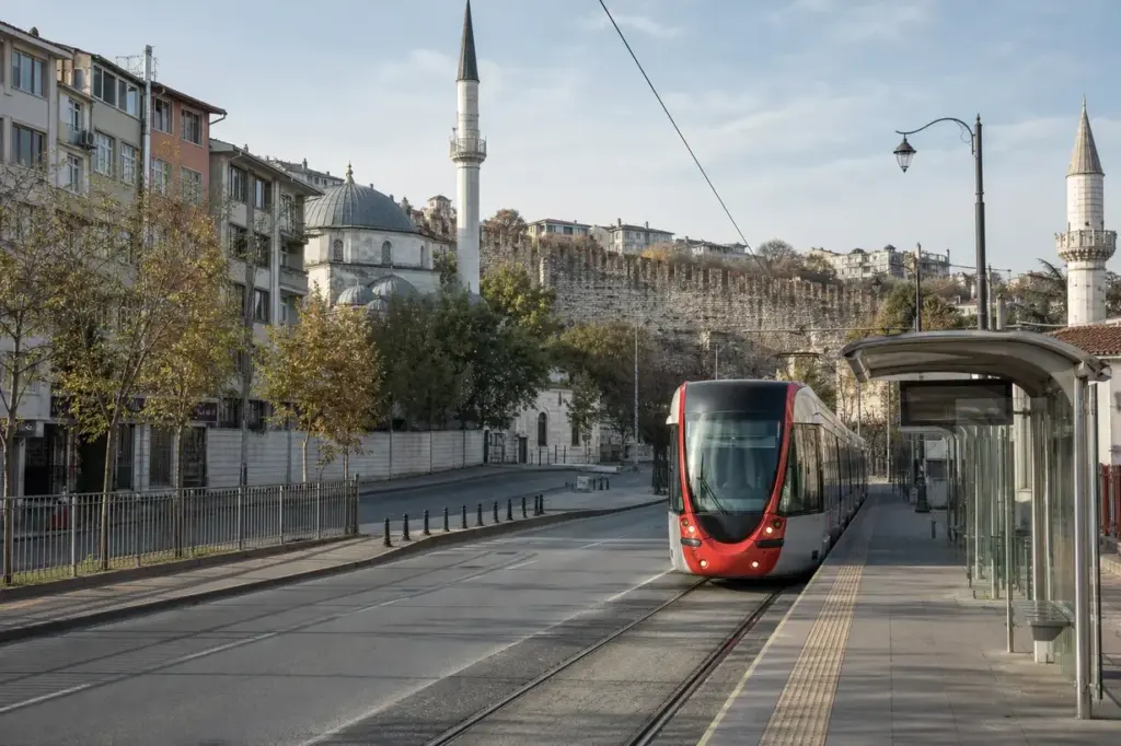
Pazartekke is a stop on the T1 tram line in Istanbul’s Fatih district, on the long street that carries the tram west from Aksaray toward Topkapı. Anyone searching for the Pazartekke tram stop will find it between Çapa-Şehremini and Topkapı, set among apartment blocks, small mosques and local shops rather than tourist sights.
It is a tram stop, not an underground metro station, and it has no hall, art or architecture to see. Its value is position: the Theodosian Walls, the Topkapı gate area and the Panorama 1453 museum all lie within a short walk, and the stop gives an easy, low-cost way to reach them from Sultanahmet, Eminönü or Kabataş.
Lines and interchanges: T1 (Kabataş–Bağcılar tram). Interchange: Pazartekke (T1 (Kabataş–Bağcılar tram)).
Quick Facts
| Turkish name | Pazartekke |
|---|---|
| Address | Turgut Özal Caddesi, Pazartekke, Fatih, İstanbul Google MapsApple MapsYandex Maps |
| District | Fatih |
| Interchanges | Pazartekke (T1 (Kabataş–Bağcılar tram)) |
| Best time to visit | Daytime on a weekday outside the commuting hours is the easiest time to travel. Early morning and late afternoon bring the heaviest crowds. Spring and autumn are comfortable for walking along the walls, while midsummer afternoons can be hot on the open stretches. Weekends are generally calmer on the commuter side. |
Why Visit Pazartekke?
Pazartekke is a practical stop rather than a destination. It puts visitors on the quieter western stretch of the T1, where the city feels like an everyday residential neighbourhood and not a postcard.
From here the fifth-century land walls are a few minutes away on foot, and the Panorama 1453 museum, which shows the siege of the city in a circular painted hall, is about a ten-minute walk. Arriving by tram also spares visitors the traffic on the busy roads around Topkapı and Edirnekapı, and it is a simple way to start a walk along the old walls.
Highlights of Pazartekke
The T1 tram on Turgut Özal Caddesi
Pazartekke sits on Turgut Özal Caddesi, the wide street that carries the T1 through Fatih. It is the seventeenth stop of thirty-one on the Kabataş–Bağcılar line, counted from the Kabataş end, with Çapa-Şehremini before it and Topkapı after it.
The tram runs at street level, so you step from the pavement straight onto the platform. Look at the destination sign on the front of the tram before boarding, because the same tracks serve trains toward both Kabataş and Bağcılar.
Tip: The route map above the doors shows how many stops remain to Sultanahmet or Eminönü.
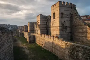
The Theodosian Walls
The land walls of old Constantinople, completed in the fifth century under Emperor Theodosius II, run from the Sea of Marmara to the Golden Horn, and a stretch of them lies only a few minutes from the stop. Visitors see the double line of massive masonry and towers, with grass and trees in the old moat zone.
The walls are an open-air site, so you can approach them freely, though some stretches have uneven ground and broken stone. Expect to walk on pavements and rough paths, and watch your footing near the base.
Tip: Walk along the outside of the wall for a clearer view of the towers than from the road.
Topkapı Gate and the Topkapı tram stop
The next stop, Topkapı, takes its name from the gate in the land walls and not from Topkapı Palace, which lies in Sultanahmet far to the east. First-time visitors often get off here expecting the palace, so it helps to know the difference before boarding.
The gate area is a busy junction of roads, with the walls rising beside it. It marks the old western edge of the city and is a good landmark for orienting yourself on foot.
Tip: For Topkapı Palace, stay on the tram toward Kabataş and leave at Gülhane.
Panorama 1453 History Museum
Panorama 1453 occupies a round hall near the Topkapı gate, and about 650 metres from the stop on foot. Inside, a large circular painting shows the final siege of Constantinople in 1453, with sound and lighting around the visitor.
It is a separate attraction from the tram, with its own ticket and hours, so check the museum's official page before going. The walk from Pazartekke follows ordinary city streets and takes roughly ten minutes at an easy pace.
Tip: Allow about an hour for the museum and combine it with a stretch of the walls.
Neighbourhood mosques and tombs
The streets around the stop hold small Ottoman mosques, among them the Kürkçübaşı Ahmed Şemseddin, Çivicizade and Mustafa Çavuş mosques, and the tomb of Oruç Baba, all within a few hundred metres. They are working neighbourhood places of worship, with courtyards and trees, and not major sights.
Visitors are welcome outside prayer times, but dress modestly and remove shoes at the door. Quiet streets here are residential, so the area feels very different from the old city's main tourist zone.
Tip: Visit mosques between prayer times and keep your voice low inside.
A first stretch of the old line
The T1 grew in stages. Its first section opened in 1992 between Aksaray and Beyazıt, and the line was later extended west past Topkapı toward Zeytinburnu and east toward Kabataş.
Pazartekke belongs to the western part of that route, which carries many local commuters, students from the nearby Çapa medical campus area and shoppers. Because of this, the stop is lively in the morning and late afternoon, and calmer in the middle of the day.
Tip: Midday on a weekday is the easiest time to find a seat.
Atmosphere
Pazartekke feels like a working neighbourhood. The tram rattles along the main street, announcements echo from the platform and people queue with shopping bags or school backpacks. Cafes, bakeries and small grocers line the pavements.
Mornings and late afternoons are the busiest, when commuters fill the carriages. Midday is slower. There are few tourists, so a visitor here sees ordinary Fatih life: older men chatting outside mosques, delivery vans squeezing along side streets and residents heading to the market.
History of Pazartekke
The land walls. The area around Pazartekke lies just inside the great land walls of Constantinople. Emperor Theodosius II had them built in the fifth century to protect the city from the west, and they remained the main defence for roughly a thousand years. In 1453 the walls were the setting for the final siege of the city.
An Ottoman neighbourhood. After the conquest, the district filled with mosques, small dervish lodges and tombs. The surviving mosques near the stop, including the Kürkçübaşı Ahmed Şemseddin and Mustafa Çavuş mosques, are part of this later layer of the city and still serve local worshippers.
The tram arrives. The modern T1 began operating on 13 June 1992 between Aksaray and Beyazıt. The route was later extended west through Topkapı to Zeytinburnu and east to Eminönü and then Kabataş, which the line reached in 2006. The tracks now join the western suburbs to the historic peninsula and the Bosphorus waterfront.
A stop in the city’s western stretch. Pazartekke is one of the stops on the western section, between Çapa-Şehremini and Topkapı. Its place on the line has given the neighbourhood easy access to the old city for local residents and made the walls and the Panorama 1453 museum easy to reach for visitors.
Tickets and Booking for Pazartekke
Fares and payment: The T1 is part of Istanbul’s public transport system, and the usual way to pay is the Istanbulkart, a rechargeable transit card that works across trams, metro, buses and ferries. Fare level for a single ride: ₺. Whether contactless bank cards, mobile payment or single-use tickets are accepted at a given stop is set by the operator and can change, so check the official Istanbul transport pages for the current options as of October 2026.
Foreign visitors: Foreign visitors can use the tram like anyone else, and the Istanbulkart is sold and topped up at machines and kiosks around the city. Rates for residents and concessions differ from those for visitors.
Busy times: The T1 is most crowded on weekday mornings and late afternoons, especially near the central stops. The western section around Pazartekke is generally calmer outside those hours.
How to Get to Pazartekke
Pazartekke is a stop on the T1 tram (Kabataş–Bağcılar) on Turgut Özal Caddesi in Fatih. It is the stop after Çapa-Şehremini when travelling west and before Topkapı.
- From Sultanahmet, Eminönü or Kabataş: board the T1 toward Bağcılar and leave at Pazartekke; the ride from Sultanahmet passes Beyazıt-Kapalıçarşı, Laleli and Aksaray.
- By metro: the M1 Yenikapı–Atatürk Airport line has a station called Bayrampaşa-Maltepe nearby, and the Topkapı stop on the T1 is the next stop for the walls.
- By bus or taxi: several local bus routes call along the same street, and taxis can reach the stop easily.
The stop is at street level, and you cross the road at the nearby crossing to reach the opposite platform.
Accessibility
Details such as ramps, level boarding and tactile paving at this specific stop are not confirmed here. The T1 uses low-floor trams on many services, but lift and platform arrangements vary by stop, so the Istanbul transport operator's pages or customer service can confirm what to expect. Pavements around the stop are generally flat, though side streets can be uneven.
Food Nearby
The streets around Turgut Özal Caddesi have the usual neighbourhood cafes, bakeries, lokanta-style restaurants and kebab shops. No single venue is named here because none was verified. Visitors can look for simple Turkish lunch places and bakeries serving pastries and tea within a short walk of the stop.
What to Bring
An Istanbulkart or another accepted payment method, comfortable shoes for the uneven ground near the walls, water, and a scarf or covering for entering mosques. A charged phone helps with directions, and sun protection is useful in summer.
Photography Rules
No stop-specific photography rules were found. A tram stop is a public transport site, so staff instructions apply and filming that blocks passengers or the tracks is likely to be stopped. At mosques, ask before photographing worshippers, and avoid photographing people at prayer.
Family Suitability
The stop is workable for families, with a simple street-level layout and short walks to the main sights. Strollers can generally board low-floor trams, but crowding at rush hours makes travel harder, and details about ramps are best confirmed with the operator. The rough ground near the walls is less suitable for small children and strollers.
Istanbul Vibes Tips
- Topkapı, the next stop west, is named after the city gate, not the palace; for the palace, travel east toward Kabataş instead.
- The tram heads in two directions on the same tracks, so check the sign on the front of the tram before boarding.
- Combine Pazartekke with a walk along the outside of the land walls toward Topkapı for the clearest view of the towers.
- Midday on a weekday is the easiest time to find a seat and see the neighbourhood at an ordinary pace.
- Because the tram runs on a busy street, cross only at marked crossings and watch for cyclists and scooters near the platforms.
- The Panorama 1453 museum has its own opening hours, so check its official page the day before planning the walk.
Explore Nearby Pazartekke
Sights near Pazartekke
 Theodosian Walls · typical visit: 2–3 hours
Main image: AI-generated illustration. It may not show the place exactly as it looks.
 Panorama 1453 – about 550 m away (~9 min walk) · typical visit: 1–2 hours2 min on foot from T1 Topkapı metro, Open daily 08:00–19:00
Main image: AI-generated illustration. It may not show the place exactly as it looks.
 Constantine Lips Monastery Ruins – about 1.5 km away (~24 min walk) · typical visit: 45 minutes to 1 hour12 min on foot from Yusufpaşa metro
Main image: AI-generated illustration. It may not show the place exactly as it looks.
Metro stations near Pazartekke
 Bayrampaşa-Maltepe – about 1.9 km away (~30 min walk)Open 24 hours
Main image: AI-generated illustration. It may not show the place exactly as it looks.
 Topkapı-Ulubatlı – about 650 m away (~11 min walk)Open daily 06:00–23:30
Main image: AI-generated illustration. It may not show the place exactly as it looks.
 T1 Topkapı – about 650 m away (~11 min walk)Open daily 05:30–00:30
Main image: AI-generated illustration. It may not show the place exactly as it looks.
Related guides
 Spice Bazaar Shopping Guide: What to Buy in Eminönü
Main image: AI-generated illustration. It may not show the place exactly as it looks.
 Chora Church (Kariye Mosque): Mosaics and Visitor Route
Main image: AI-generated illustration. It may not show the place exactly as it looks.
 Blue Mosque Visiting Guide: Prayer, Courtyard and Tiles
Main image: AI-generated illustration. It may not show the place exactly as it looks.
 Topkapı Palace Visiting Guide: Courtyards, Treasury and Harem
Main image: AI-generated illustration. It may not show the place exactly as it looks.
 Hagia Sophia Visiting Guide: Entrance, Dome and Mosaics
Main image: AI-generated illustration. It may not show the place exactly as it looks.
Browse more: More in Fatih · All Metro Stations · All Other Hubs
FAQ: Pazartekke
Is Pazartekke a metro station?
No. Pazartekke is a stop on the T1 tram line in Fatih, at street level on Turgut Özal Caddesi. It has no underground hall. The nearest metro connection is on the M1 line, and the tram links with other transport at stops such as Aksaray.
Which line serves Pazartekke?
Only the T1 tram, which runs between Kabataş on the Bosphorus and Bağcılar in the west. Pazartekke lies between Çapa-Şehremini and Topkapı on this line. Check the front sign of each tram for its destination before boarding, since trains run both ways.
How far is Pazartekke from Sultanahmet?
The tram ride is a direct one on the T1, passing Beyazıt-Kapalıçarşı, Laleli and Aksaray on the way. The journey takes a little while and depends on traffic and crowding, so allow extra time at rush hours and use the route map in the tram.
Is Pazartekke near Topkapı Palace?
No. Topkapı Palace is in Sultanahmet, on the eastern end of the historic peninsula. The Topkapı tram stop near Pazartekke is named after a gate in the land walls. Visitors heading for the palace should travel toward Kabataş and leave at Gülhane.
What can I see near Pazartekke?
The Theodosian Walls are a few minutes away on foot, and the Panorama 1453 museum is roughly ten minutes beyond them. Small Ottoman mosques and the tomb of Oruç Baba stand in the nearby streets. Most visitors combine the stop with a walk to the Topkapı gate.
Is Pazartekke good for tourists?
It is mainly a local stop, used by residents and students. It suits visitors who want to explore the walls and a quieter residential side of Fatih. Those wanting major landmarks are better served by stops nearer Sultanahmet and Eminönü.
How do I pay for the tram?
The Istanbulkart is the standard card for the T1, with a fare level of ₺ for a single ride. Other options depend on the operator's current rules, so the official transport pages are the reference. Visitors can buy and top up the card at machines and kiosks.
Is the area safe and easy to walk?
Fatih around the stop is a busy residential area and generally easy to navigate in daytime. Streets can be crowded with traffic and uneven near the walls, so a sensible routine of staying on pavements, using marked crossings and keeping bags closed is enough.
Istanbul Vibes is a one-person project. A coffee keeps it going

Take this guide with you
Get a free PDF of this guide to print or read offline: key facts, tips and a map link on a few clean pages.
Report an issue on this page
How we research and update our guides
About this guide: AI assistance and accuracy
This guide is created with the help of AI and is based on official sources where available. Mistakes can still happen. Opening hours, prices, rules and other details are given to the best of our knowledge as of the date shown and can change without notice. It offers general recommendations only, not professional, legal or travel advice. Please confirm important details with the official source before you travel; you are responsible for your own plans and decisions.
* Affiliate link: as an Amazon Associate we earn from qualifying purchases at no extra cost to you.